Wokingham in the 1960s, 70s & 80s
We have lived in Wokingham since 1967, and over the years I took many pictures in and around the town of things that have either changed or gone completely.
Langborough Road
We first lived in Langborough Road. Most of the houses remain but the shop closed and was turned into offices and later abandoned. The phone box and letter box that were on the shop forecourt have also gone. The GPO replaced the red phone box with a new style metal & glass one but they didn't consult the owner of the land, who insisted it be changed back to the original, as a result of which it was just removed.
There were two garages next to us, in the corner of the large garden of Saxham Lodge, but they went and the garden was walled in when the house was demolished and replaced with a block of apartments.
Before the early 1970s Murdoch Road didn't have pavements – just a gravel path along the middle of the verge on each side. But the road was metalled, unlike Southlands Drive.
No 1 Murdoch Road was a large private house, with several big pollarded poplars in the front (visible in the picture of Murdoch Road). The trees were cut down after the building was extended at both ends and turned into a care home.
Click on any picture to enlarge, and then use the arrows to move between pictures.
Luckley Path & Ludgrove
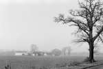
Luckley Path leads over the railway towards Ludgrove, with views of Chapel Green farm and Lucas Hospital across the fields.
Sadly the whole area will soon be changed for ever with a new road and hundreds of new houses. You can see pictures taken in all seasons between 2008 & 2022 of what we will lose.
Click on any picture to enlarge, and then use the arrows to move between pictures.
See also: pictures of this attractive area between 2008 & 2022
Wokingham town
At the top of Howard Road there used to be a Hawthorn Tree in the middle of the turning area, but now it's just tarmac for parking. There was often a large puddle between there and the Cockpit Path car park. There's a drain now so it floods less often.
The timbered building at the top of the picture of the Market was the old Kings Head. It was saved from total demolition but the left hand part was replaced with plain brick, and although the right hand part is timbered it is completely new – different windows and more closely spaced timbers.
The Peach Street car park is no more, and the demolished building on the corner of Rose Street has been replaced. Note Holes ironmongers on Broad Street, which was one of several in the town.
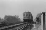
The two coach train from London shows how much less commuting there was (now all trains are eight or ten coaches). The siding north of the station has also gone.
The picture of London Road near St Crispins is where the Leisure Centre now is, and the area by the lay by cafe has changed completely with the development of housing there.
Click on any picture to enlarge, and then use the arrows to move between pictures.
Towards Bracknell
For 17 years I cycled every day between Wokingham & Bracknell, and the 1972 picture shows the old road heading over the hill and down towards St Anne's (which was then a nunnery). The main road was diverted to the north of here, and down to the new Coppid Beech roundabout when the motorway was built .
By 1975 the motorway was open, but some ancillary work was still incomplete. At the time we lived on the Beanoak estate and the motorway cut across our regular Sunday walk, both the footpath and Binfield Road.
In 1981 the line of the motorway was extended along what is now Berkshire Way. That cut through Beehive Road, which was a quiet way to go from Binfield to the ICL (now Fujitsu) building on Peacock Lane. The level crossing on Beehive Road was replaced with the most awkward footbridge I have ever pushed a bike over.
Turning right along Peacock Lane takes you past the entrance to Easthampstead Park, which has hardly changed, and then back along Easthampstead Road to Wokingham.
Click on any picture to enlarge, and then use the arrows to move between pictures.
If these pictures bring back memories, feel free to get in touch . If you think I've remembered anything wrongly, or you would like me to add a link to some other old Wokingham pictures, then please let me know.
All material Copyright © John Harrison 1968 – 2020
You may also be interested in: Building the A329(M) The countryside south of Wokingham – before being built on Pictures of Elms Field – before and after building